

GPS Study Maps Elephant Movement Across Assam, Highlights Key Corridors

GUWAHATI, October 6, 2026 — A five-year GPS telemetry study by the Assam Forest Department and WWF-India has shed new light on the movement and habitat-use patterns of wild elephants across Assam, providing crucial evidence for conservation planning and human-elephant conflict management.
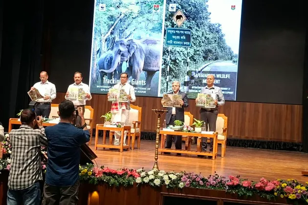
The findings are detailed in a new report, Tracking the Giants: Movement and Habitat-Use Patterns of GPS-Collared Elephants in Assam, released on Tuesday by Assam Environment, Forest and Climate Change Minister Jayanta Mallabaruah during the 72nd Wildlife Week event in Guwahati.
Between 2021 and 2026, researchers fitted GPS collars on four female-led elephant herds and one solitary male elephant across the human-elephant conflict-prone districts of Udalguri, Sonitpur and Biswanath. The study generated more than 38,000 GPS locations, providing high-resolution data on seasonal elephant movements across forests, tea plantations, agricultural areas and riverine landscapes.
The study found that Sonai Rupai Wildlife Sanctuary, Behali Wildlife Sanctuary and Bornadi Wildlife Sanctuary are among the important habitats extensively used by the collared elephants. Protected areas and reserve forests remained key habitats for much of the year, while tea plantations also served as significant movement pathways and secondary habitats, often bringing elephants into close proximity to human settlements.
The home ranges of female-led herds expanded during the paddy cropping season, which also coincided with a period of heightened human-elephant conflict.
The elephants were also observed using river channels to move north-south between the forests of the Himalayan foothills and the Brahmaputra grasslands, locally known as chaporis. The finding provides important insights into elephant movement routes across Assam's multi-use landscapes.
Several of the identified movement routes intersect roads, railway lines and human settlements, highlighting the need for mitigation measures and safeguards to reduce risks to both people and elephants.
The study also recorded transboundary movement between Udalguri in Assam and the adjoining Jomotsangkha Wildlife Sanctuary in Bhutan during the dry season. The researchers said the finding underlines the need for greater coordination between India and Bhutan to conserve elephant corridors and manage wildlife movement across the international boundary.
Dr Vinay Gupta, Principal Chief Conservator of Forests-Wildlife and Chief Wildlife Warden, Assam, said the report fills a major knowledge gap regarding elephant presence and movement in the state.
He said the five-year study provides baseline information on elephant ranging patterns, particularly in areas where elephant movement overlaps with human land use, and would help inform conservation strategies and strengthen human-elephant coexistence measures.
Aritra Kshettry, Lead for the Elephant Conservation Programme at WWF-India, said the GPS telemetry study had helped identify core natural and secondary habitats used by the collared elephants and revealed strong seasonal movement patterns.
He said understanding where elephants move, how they use different habitats and land-use types, and how these patterns change with the seasons would be critical to effectively managing human-elephant conflict.
The report is expected to provide an evidence base for securing elephant habitats and movement corridors in Assam while supporting landscape-level conservation planning and safer coexistence between elephants and local communities.
Comments (0)
No comments yet. Be the first to share your thoughts.
Leave a Comment