

Did the highway push in Nagaland's hills make Assam's flood worse?

The Disang river at Nanglamoraghat crossed 96.49 metres on July 20, breaking a record set in September 1998. The Dikhow broke its own record days later. By the time the water started to recede, more than 3.7 lakh people across Sivasagar, Charaideo and Jorhat had been counted as flood-affected, dozens of embankments had failed, and the rail line to Dibrugarh was underwater.
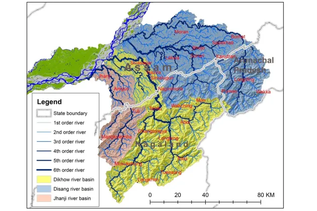
Dr Sarat Phukan, Assistant Professor in the Department of Geological Sciences at Gauhati University, posted a basin map of the Disang, Dikhow and Jhanji rivers soon after, along with a detailed explanation of why this flood behaved so differently from the Brahmaputra floods Assam is used to. The post has since circulated widely. It points, carefully, at the hills.
A river basin ignores the state line
A drainage basin is simply the land from which rainwater feeds a river. Phukan's map shows the Disang, Dikhow and Jhanji basins running from the Longding-Tirap and Mon belt in the east to Mokokchung in the west, crossing Nagaland, Arunachal Pradesh and Assam as one connected system. Rain falling on a Naga hillside has nowhere to go but down, through the small streams that eventually reach Sivasagar and Charaideo.
The rain this time was extreme by any measure. Mon received about 130 mm on July 19, Mokokchung 126 mm, according to figures from the Nagaland State Disaster Management Authority. A separate report covering the wider spell put Mokokchung's total at 238.9 mm, nearly five times normal for the period, with Zunheboto and Kiphire also recording several times their usual rainfall.
The rain explains the flood. It does not, on its own, explain why two rivers broke records that had stood for 27 years.
What the highways did
This is where Phukan's post gets specific, and where this newspaper pressed further. Development in the Naga hills has been sold for years as the thing that would finally connect the region and lift it economically. The question now is whether some of that development has quietly worked against the people downstream.
Phukan does not blame highways outright. Four-lane roads and elevated rural corridors, he writes, are not inherently the problem. The trouble starts when the bridges and culverts beneath them are too few or too small, or get blocked with debris. A road embankment without adequate cross-drainage stops behaving like infrastructure and starts behaving like a dam: it holds water back on one side while cutting off the drainage villages on the other side have relied on for generations.
Chief Minister Himanta Biswa Sarma, touring the affected districts this week, made a similar point without Phukan's hedging. Assam's geography means excess water from Nagaland always flows down to the plains, he told reporters, but he added that new roads and industry in the hills have made things harder for people downstream in Assam.
Assam Times' own feature on the flood, "Cloudburst Claim: What Really Caused Upper Assam's Flood?" (published July 24, unbylined), goes further than Phukan on this point. Drawing on two years of visits to the upstream and downstream catchments, its author writes that riverbed levels are rising while the rivers' capacity to carry water is shrinking, and names railway lines and highways specifically: built across the landscape without adequate passages for water to flow naturally, the piece argues, they have made the terrain more complex and worsened this flood. The same piece describes mining that has cut into riverbeds directly, and road-building that pushes excavated soil and debris straight into streams. A channel with less room to carry water backs up sooner. Across a basin that has seen years of road cutting, that can turn a heavy monsoon spell into a record flood.
The rain still decides
None of this changes what triggered the flood. It rained exceptionally hard, on ground that was already saturated. Phukan is explicit in his post that the actual contribution of roads, mining and construction to this particular flood needs to be established through scientific study, not read off a map.
He lists wetland filling, brick kilns, unregulated construction and unscientific coal mining in the hill districts, along with deforestation, as factors that may have worsened the flooding. Each takes away the land's capacity to hold water, or blocks a path water used to take, and passes the consequence downstream, usually into someone else's state.
What Phukan's post leaves for the next flood
Phukan's post ends on memory rather than blame. He writes that flood memory must never lapse inside government institutions, which are responsible for forecasting and embankments. He also writes that it is fading inside floodplain communities, where families are growing more isolated and the job of coping with disaster has been handed over almost entirely to the state.
He calls for both to work together: government systems that don't forget, and communities that rebuild the cooperation that once got people through a flood before help arrived.
This feature draws on a social media post and drainage-basin map by Dr Sarat Phukan, Gauhati University; Assam Times' feature "Cloudburst Claim: What Really Caused Upper Assam's Flood?" (24 July 2026); and rainfall data from the Nagaland State Disaster Management Authority.
Comments (0)
No comments yet. Be the first to share your thoughts.
Leave a Comment